Tenquille Lake: Summer Grand Finale
This has been an amazing summer. It started kind of slow with a very wet June, but July and August were pure sun. We’ve been lucky enough that this sunny weather continued on into September. On the first official day of fall, Gili and I headed for a three day trip to Tenquille Lake, as a finale of this wonderful summer. In the next couple of weeks we’ll be visiting our families in Israel, and by the time we’ll be back it’s probably going to be full-on fall.

The drive was quite long, past Pemberton and then on to the Birkenhead Lake road. As we were driving the logging road we noticed smoke coming from a nearby valley. We managed to drive most of the way, but decided (smartly) to park before the first creek crossing. Then as we were just getting ready to leave, a Subaru Forester showed up. We didn’t expect to be able to catch a ride, as this was a Friday, but we got lucky. This couple with two rifles and one dog was just driving up there for fun. The Forester was doing quite well, but it was the classic scenario of the woman telling the man that she doesn’t think they should continue farther and the man just driving through, banging the rear end of the car on some rocks and whatnot. Eventually they dropped us off just a few meters before the trail head. Sweet.

But we had to make our first stop even before we reached the trail head. The reason for that was huckleberries. The biggest, juiciest, sweetest and purplest huckleberries I’ve seen in my life. And I thought that two weeks ago in Manning we already encountered the best berries ever. So we stopped for a while, picking and eating. The approach to the hut and Tenquille Lake was really short, and we were there in just over an hour and about 200 meters elevation gain…
By the lake there was a group of four people and two dogs who were quite surprised to see us. They had come up the Hurley side and didn’t even know about the trail we had used. They were just day hikers so after they left we had the whole place to ourselves. We cannot say the same for the next two days… We had lunch by the lake, and then jumped in for a swim. It was cold, but not as cold as some other lakes we recently swam in in the Rockies. It was really warm in the sun, so getting out of the water was very pleasant. There was also a yellow sit-on-top kayak there, so Gili took it for a paddle around the lake, while I enjoyed my wonderful book in the sunshine.

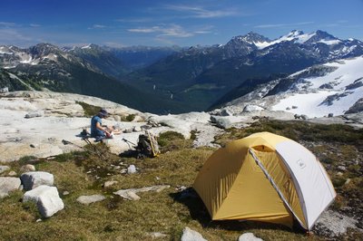
Then the sun disappeared behind the mountains, and we went to check out the new hut, built in 2011. It’s big, looks comfortable and even has light fixtures. People must have put a lot of effort into it. We didn’t intend to stay in the hut, so we went to pitch our tent and cook dinner by the lake.
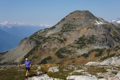
On Saturday we headed to Tenquille Mountain. The route was pretty much straight up, and we gained elevation quickly. Then there was some nice ridge walking until we finally reached the summit plateau. This mountain didn’t seem to have one designated summit so we just moved from one corner to another, checking out the glacier below us and the great views. The only problem was that because of the smoke the visibility was quite hazy. Still the views were amazing, and it was warm.

After lunch we traversed to Goat Mountain., which involved a bit more scrambling. It was lots of fun, and this time there was one obvious summit. The descent from Goat wasn’t that great though. It involved a long section in a steep and rocky gully, the only neat part about it was when we walked underneath a snow bridge, which had lost a piece from the top.

I was very happy to be back at the lake, and we discovered that we no longer had the place to ourselves. The hut had filled up with people and there were also a few tents near the hut. Luckily our camping spot was a bit farther away, so it didn’t really bother us. Dinner was well appreciated that day, and crawling into the sleeping bag was a delight.
We woke up to a beautiful sunny morning. The haze from the day before seemed to have faded away, so the visibility was better. After breakfast we headed to the other side of the lake and scrambled up Mount McLeod. There were great views towards the Pemberton Valley and the Hurley. We kept on seeing that ugly and loose gully we descended from Goat, and it looked even worse from a distance.

Once back at camp we had lunch, packed up and jumped into the lake for one last swim. The descent back to the trail head was pretty quick. We had some berries while coming down, but not as many as we hoped, as there were people who were just leaving and offered to give us a ride to our car. At least we didn’t have to walk the whole logging road, so it was worth it. We found a few bushes near our car, but they weren’t as good as the ones higher up. The nice people in the car gave us a Strongbow (alcoholic cider), as they always finish a hike with a drink. Since Gili was driving I had to drink most of it. When we neared Pemberton I asked Gili to stop at a gas station so I could pee. There we randomly met a group of VOCers who were just coming back from a work hike on the trail to the Harrison Hut.

On the drive back we picked up a hitchhiker, dropped him off in Whistler and then picked up two more immediately after dropping him off. A few minutes later we picked up another one. We met Adriana and Piotr’s cars at the excellent Indian restaurant in Squamish (Essence of India). We filled a table for seven and enjoyed an excellent meal in good company.

3 Comments
Otto
Hi There,
Sounds really nice and a new hut, excellent.
Could you please tell me how to go in and find the trailhead?
I have a 4 wheel drive.
Thanks,
Otto
Gili
Hi Otto. I used the directions from the excellent guidebook Scrambles by Matt Gunn. The road condition has changed over the years, but currently it seems a bit better than in the book and with 4wd and high clearance you should be able to drive to the trail head with no trouble. There are good directions on ClubTread – we used the access marked as number three. It offers the quickest access on foot, but also demands the most driving. For completeness, I quote the Clubtread description here, with a few small changes:
Drive north on the Sea to Sky Highway (#99), passing Pemberton. At the intersection in Mount Currie, follow the sign towards Birkenhead Provincial park – go straight and do NOT turn as if you were driving to Lillooet. Turn left at ‘Pemberton Portage road’, which is roughly 17km from the intersection in Mt Currie. Take the first left, just after the railroad tracks. Keep going straight for just less than 10km, then veer left/straight onto the Birken/Tenquille Main Line. Just after 16km, go left on the Birkenhead River/Tenquille Creek branch. There are two creek crossings, with 2wd low clearance we managed to drive to the first creek crossing at about 2.5km from this intersection quite easily (there are some easy water bars though). With 4wd high clearance, drive to the end of the road, where the trail begins. The trail is well used and easy to follow. When you reach the lake, there are two trails, and going left or right will take you to the cabin, which is on the other side of the lake. It took us around 1 1/2 hours to the cabin from the trail head.
Otto
Thanks for the info Gili, will be heading there the coming weekend.