Wind Lake: Ben More and Ben Lui

It was hot and sweaty. Flies kept on circling around my face, buzzing to their heart’s desire. Every now and then they landed on me, and I’d swat at them, killing the slowest ones. We were stuck in a Catch-22. We wanted to stop in one of the rare patches of shade to cool down, but the heat brought flies that would swarm us if we stopped. So we kept going. I was starting to think this trip to Wind Lake would be the definition of hell, but from there and on it only got better, and I mean much better.

As we got higher along the the trail, we started seeing some views down the valley of Furry Creek. Farthest, in the distance, I could see a sliver of ocean – Howe Sound, the turquoise fjord that leads from Vancouver to Squamish. Closer, there were many old clear cuts, and two very new ones. The devastation was apparent – where there was a live and healthy forest, the loggers left nothing but brown soil. Even after many years, once trees have been replanted and hopefully grown, the forest will remain scarred.
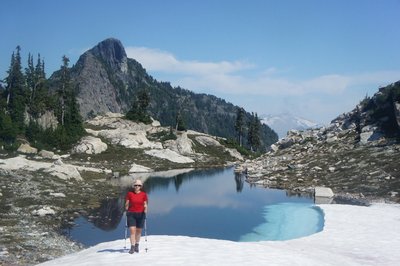
We switch backed up through an old clear cut, on an old logging road that no longer resembled a road, now just a trail. Eventually we reached mature forest, where we finally enjoyed some shade and a much more interesting forest to look at. The trail traversed the hill side, finally cresting a hill to Wind Lake. We were surprised to see that the lake was half covered in snow, which didn’t bode well for the plans for a refreshing swim. Still, I made a valiant attempt at a swim that fizzed out and turned into a quick dip. After a relaxing lunch we put up our tent on a rock ledge overlooking Wind Lake, and set out for some off trail rambling.

Our first destination was a nearby peak, Ben More. The peaks in this area are named after Scottish Munros – peaks over 3,000 feet in height, which explains why many of them have the prefix “Ben”. Our route meandered between a series of small waterfalls, along colourful rock slabs, and finally up a series of small cliffs to the summit. On the way up we enjoyed good views of the Skypilot group, and of the nearby Red Mountain and the pointy Ben Lomond. We set our sights on the latter, first trying a direct route along the ridge that was blocked by steep cliffs and then scrambling down to a snowy bowl and back up onto the ridge. After being stymied several times in our search for a route along the ridge, we ran out of time and turned around.

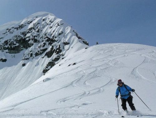
Back at camp we had a relaxing dinner and a quiet night – there appeared to be no other people in the area. Sometime during the night it began raining hard, but it only lasted for a few minutes. When we woke up, the sky was blue and the sun was shining, but soon a strong wind began blowing and clouds began billowing past Wind Lake, perhaps explaining the lake’s name. After breakfast we packed up our gear and set out again, this time setting our sights on Ben Lui. By the time we got going we were engulfed in clouds. We followed the trail for a bit and then left it to follow a series of progressively steeper heather slopes, ending in a gully that led to the summit plateau, above the clouds. We identified many peaks, including Skypilot, Ledge, Sheer, Garibaldi and Mamquam, all of which protruded out of the sea of fog, like seals coming up for air. After enjoying the view for a long time, we descended via a more direct route that involved a convoluted path through steep cliffs.

We set out again down the same trail, which had changed its face from the satanic one of the day before, to a more delightful. At one stage we heard voices and then loud barks, and two people and three dogs emerged from the foliage. Those were the only people we saw on the trail that weekend. It’s surprising that despite the easy access and short driving distance, this area does not see more use. It definitely retains a feeling of wildness, which is all the more compelling for the visitor.

Six years ago, when we arrived to Vancouver, our second hiking trip was to this area, to the Mountain Lake Hut, just a bit farther along the same trail. That trip was a beginner friendly trip with the Varsity Outdoor Club, so all we had to do was follow the leader. Since then we had thought about this area every now and then, but only had a vague idea of where it is located. It was fun to return to a place that we had visited many years ago and discover that although it seemed somewhat familiar, it was unfamiliar enough for it to feel completely new, and for it to fill us with a sense of wonder again. It’s a bit like re-reading a book that you read many years ago, and finding that you barely remember the plot and can enjoy it almost as if it was the first time you were reading it. Perhaps that’s the strength of a bad memory…
One Comment
Tal
Hahaha, it runs in the family! 🙂