Ellensburg-Vantage-Yakima Loop: The US is a Funny Place

Our desire for sunshine took us far and away last weekend. We set our eyes on an area in Washington State that we visited before, but many years ago. It’s hard to believe but it’s a real desert, very dry and most importantly warm and sunny. Gili managed to dream up a three day loop that looked neat, so on Saturday morning we found ourselves again waiting in the long line-up to cross the border to the US. Finally we were on the other side but still had a few more hours to drive. The roads we took were very green with snowy peaks and it was cool and gray, so it didn’t quite feel that we were indeed on our way to the desert. When we finally reached Ellensburg, the town we started from, it was way past lunch time. I remembered from last time that there was good Mexican food there, and sure enough we asked two guys who immediately pointed us to the nearest taco truck (Tacos Chalito). The food was delicious and the prices were ridiculous – the super burritos were $3.50

We found a place to park near the university where there was a graduation that day, so there were many cars around. It was chilly and windy, not at all typical desert weather. As we started to ride along the old Vantage Highway we could feel the strong tail wind that made us move very fast, even though we were on a slight uphill. We passed a sign advertising electronic supplies as well as guns, the US is a funny place…

As we moved on many windmills started to appear on both sides of the road. After about 25km the nice fast uphill turned into a terrifyingly fast downhill. The wind was blowing so hard that I actually thought it was going to knock me off my bike. It had never happened to me that I had to walk sections of a downhill on the road, and even when I walked I still thought I was going to fall off. I’ve been having trouble with downhills anyway since the injury, so that wasn’t making things better. But eventually I managed to ride most of the way down, and the cycle computer even showed that I reached 50 km/h (Gili went over 60 km/h). We stopped at Gingko Petrified Forest State Park for a short hike to see petrified logs from different types of trees, an indication that this dry area was once covered with forest. We reached the very small town of Vantage (a “one horse town”) and from there continued a bit more to Wanapum State Park, a really nice campground near the Columbia river.

The wind blew very hard during the evening and night. I kept on waking up because the tent shook so hard, it felt like a scene from the Wizard of Oz. The wind only calmed down in the morning as we woke up to a beautiful sunny warm morning. We packed up and carried on riding along Huntzinger Rd., now along the impressive Columbia river, passing a the large Wanapum Dam on the way.

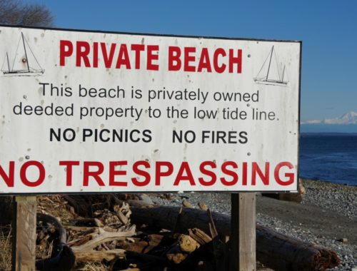
Then a weird thing happened, the road stopped and private property begun, leaving us with no choice except for trespassing in order to continue on. We rode through some orchards until we finally made it to the road again, but the road was now bumpy gravel which made our progress slower and made it harder on my arm. Nonetheless the road was beautiful, still along the Columbia with no other people around, which gave it a very isolated and adventurous feel. But then once again we reached a private property road. This time there was a gate that we could open and we found ourselves surrounded by cherry trees, with ripe cherries on them, with no one else around. It was hard to resist. When we reached the other end of the orchard there was a gate again, this time a locked one. With a bit of climbing and carrying the bikes over we were soon on the other side. I don’t understand how it works and how people are supposed to get through, as both the state map and Google maps showed that it is a legit road. The US is a funny place…

We reached the main road (SR 24) and we were ready to eat, it was getting really hot and of course there was no shade anywhere… The last shade we saw was at the cherry trees, but we didn’t want to stop there as apparently we were trespassing. So we carried on, hungry, tired and hot, and of course it was all uphill. Then in the distance we saw a flag and thought maybe it’s a good sign that a gas station, a store or someplace with shade would appear. But what we found was a gate that led to something that looked like an army base. In chatting with the guard Gili discovered that this place is actually a nuclear weapon facility (the Hanford Nuclear Reservation), which was a part of the “Manhattan Project” in 1943. Apparently Plutonium manufactured there was used in the first nuclear bomb, and in the bomb dropped on Nagasaki, but now they are mostly cleaning the place up. The US is a funny place… The only shade we found in the area was from a solar panel, and we had a good lunch and a bit of rest under it.

The next part of the ride was a bit boring as the scenery was less interesting after the scenic ride along the Columbia. We were on a slight uphill and going against the wind, it was very hot and our progress was slow. But as soon as the grade changed to a slight downhill we felt as we were flying along, the mood changed and smiles were all over our faces again. It was getting quite late in the day and we knew that we would need to find a place to camp soon, but on both sides of the road there were fences with private property signs and/or no trespassing sings. There was no public land, campgrounds or recreational sites, the US is a funny place…
Gili suggested that we just ask people if we could sleep in their yard. I must admit that I was quite skeptical. It’s the US after all, not Mexico where we tried this method with no problems. Also, there were fences and gates that separated us from the potential people that we could sleep at. Eventually we found a side street with a house with no fences or barriers and the family was even outside. We said we just needed a place to camp for the night. They happily agreed with no hesitation and showed us a few places where we could pitch our tent. They had a perfect spot in their backyard, almost like it was made just for that.

We could use the bathroom in their house whenever we wanted, and they always leave the door open, as they “live in the boonies”. Their house used to be an old cow milking house, and they are renting the place and taking care of the goats that belong to some rich people who bought it from other people who went bankrupt. The US is a funny place…
In the morning our hosts were already gone and we enjoyed their views from the back yard, including one very impressive snowy mountain (probably Mt. Adams). They told us about a path that would lead us part way to where we wanted to go, without taking a main road. So we rode to the town of Yakima and from there we took the Green Way path.

It was very nice, all paved and along the river, and restricted to non-motorized vehicles. The only trouble was that the forks were unmarked and there were several trails and eventually we took the wrong path. It was really hard to navigate with no map or clue where we were going. Two cyclists led us in the wrong direction that made us do a detour where I also got a flat tire from a large nail. Then we asked several more people and everyone was really nice and tried to help out. Eventually a nice woman gave us a map and we went back on the Green Way and took a different path that led us to Selah, the town we wanted to get to.

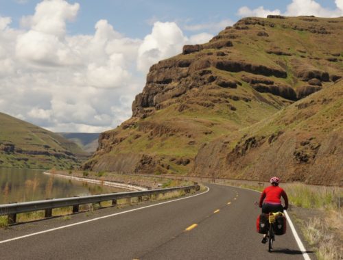
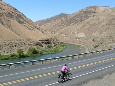
From there we had to find our way to the “Canyon Road” (SR 821). All the people we asked told us two things – that it is a beautiful road and to watch out for traffic. The traffic proved to be no problem, because there was hardly any at all, and they were right, it was beautiful, probably one of the most scenic roads I’ve ever ridden. It was on a cliff edge over looking the Yakima river on one side and a canyon wall on the other. The only problem was that it was midday and the sun was baking us. When we got down to the river level Gili jumped in to cool off and splashed me a little bit too.


We weren’t sure how long we would still need to ride, because the detour from before added on a good few kilometers, but eventually we saw signs of civilization and were back again in Ellensburg. However, just as we entered town Gili got his third flat tire on the trip and again had to stop to fix it. The other one was just a couple of hours before that, when we were still on the Canyon Road. We got back to our car close to 7:30pm, a bit later then anticipated and very hungry. So of course we paid another visit to the now familiar Taco Truck. Ellensburg was very quiet, with the graduation over and only a few students around. This desert university town really reminded me of Beer Sheva, with the same type of atmosphere.

The drive back was very long and we actually got stuck in traffic since Snoqualmie Pass was closed intermittently for rock blasting … We only crossed back to Canada after 1:00am and went to sleep around 3:00am. Just a few hours later I woke to a gray and rainy morning and went to physio. The desert scenery and feel were a vague memory and almost felt like a sweet dream that never happened.

Notes on this route: we parked near the corner of Brick Rd and E University Way in Ellensburg – if you take exit #106 off Highway #90, it takes you straight there. We then rode along University Way which turns into the old Vantage Highway, right into Vantage, where it changes name to Main St. Following this road, it crosses Highway #90 and changes name to Huntzinger Rd. Continuing along this road for a short way, we reached the Wanapum State Park Campground (bike camping is only $12, available even if they are “full”), there is also an RV campground in Vantage (not as nice). The next day we followed Huntzinger Rd along the Columbia River, passing the Wanapum dam and then some apple orchards (keep just to the right of them). Then we picked up a small gravel road that follows the shore of the Columbia River closely, changes name to Priest Rapids Rd. (unsigned) passing a second dam. There is a section here of very old road that appears on some maps which was nice to ride along for a change. We then reached a cattle gate leading to a cherry plantation (ask for permission to cross their land), once on the other side, follow this road to State Route #24 and to Moxee, where we camped (in someone’s backyard). The next day we continued along the same road to the outskirts of Yakima, where we picked up the Greenway opposite the K-Mart, in the parking lot of the Humane Society. There is an essential unsigned left turn after passing underneath Highway #97 (double bridge), which takes you across one of the bridges, and the Greenway continues right into Selah. From there we rode along the main street, turning right on Wenas Rd. (signed for #823), and then right to Harrison Rd. which leads to the Canyon Highway (#821). Just before reaching Ellensburg, we took a right turn onto Thrall Rd. and a left onto Number 6th Rd. and then finally left onto the old Vantage Highway and back to the car. The distances we rode each day were roughly: 50km, 100km, 100km. One could break it more evenly with some (beautiful looking) stealth camping, the first night along the Columbia River, and the second along the Yakima Greenway, or in a campground in Yakima.