Pemberton Icecap Traverse: From Superstition to Irony

This trip was seemingly ruled by superstition. It started with Ben’s curse. Ben had been trying to reach the Harrison Hut for many years. Invariably, he failed, often due to natural disasters. Of note were the landslide that closed the Sea to Sky Highway for almost a week in July 2008, and the massive lahar off Mt. Meager in August 2010, perhaps the largest recorded slide in Canadian History. Aside from that, there were apparently some other attempts foiled by bad weather. I had been warned by others, before this trip, that if we tried to approach the Harrison Hut with Ben, all hell would break loose. And it did!
Then there was the Whiteout Curse. At some stage we started calling Sam “Whiteout Sam”, perhaps it was even my fault. At first it was a joke, but as the trip continued, the whiteout stayed around, so the nickname stuck. We joked around about one day changing the nickname to “Sunshine Sam”, but it never happened. We had one day of beautiful weather and seven days of whiteout. Sometimes the sun would tantalize us with its rays for an hour before disappearing. Three of the participants in this trip: Piotr, Sam and Champagne had just returned from the Bridge-Lillooet Traverse three days before we left. The forecast for our trip was not looking good, but I figured, if those guys thought it was a good idea despite spending days and days in a storm, they probably had a point.

Imagine this: you are floating in a pure white cloud. It is soft as a cotton ball, and yet as impenetrable as the smoke of a fierce forest fire. You are in the front, breaking trail in soft slushy snow, or breakable crust, following a compass bearing of 238 degrees. Every now and then you can make out a shape in the distance, perhaps, or maybe you just imagine it, but most of the time it is just a uniform white. You look around you, hoping to catch a glimpse of the undoubtedly incredible views which you cannot see. You wonder about inventing goggles that can see through fog, all that Physics education (a PhD soon) should be good for something, but you keep trudging on. The sun comes out sometimes. Sometimes just for a few minutes, and sometimes for two hours. These gaps in the weather are classified as either “Weather Windows” if they are long, or “Sucker Holes” if they are short, and the distinction is rather fine.

The night before the trip, some of us were concerned about the warm weather and the beginning of our route, which passes below large south facing slopes – we didn’t want to pass below those slopes in the afternoon, when they’d be most active. We were pondering starting with a first short day when Champagne decided it for us: he had forgotten to pick up his boots from the repair shop, which only opened at 10am the next day. A few of us sighed in relief: we’d sleep a few more hours, and get a relaxed start. We picked up Sam in Pemberton and drove on road and then gravel to the beginning of South Creek FSR, which was covered in snow right from the start. Ouch! We had hoped to drive up it at least a few km’s. We tried to push Piotr’s jeep up the road, which involved much grunting and shoveling, but after a few hours we had only moved by a km or two, so we parked the vehicle and started hiking.

I was somewhat sorry I hadn’t weighed my backpack, since the talk in the car had revolved around how heavy everyone’s 9 day backpacks were. Piotr won the contest with a 95lb pack, but he’s a big guy, and he and Sam were extending our trip so they had gear for 12 days. Hiking up the road with his skis in his hands, Piotr was visibly suffering, in fact, a few times I thought he might fall over. This was both due to the ridiculously heavy pack and lack of sleep. Somehow Piotr had managed to sleep just three hours the previous night, despite the delay in our departure. Apparently he had spent several hours at a friend getting a kite, hoping to use it to sail across the icefield, but ironically decided in the end that the kite was too heavy and ended up leaving it in the car. I was also feeling weak on this day. We didn’t make much progress and camped on the road, at a conveniently flat switchback. We decided to wake up early the next day, to try and make it through the avalanche prone terrain earlier, rather than later.

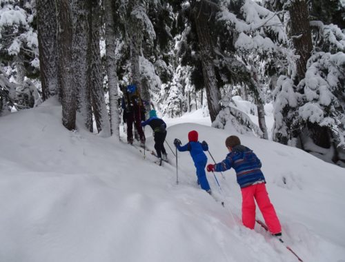
The second day dawned sunny with blue skies, and we were optimistic: perhaps the forecasters had gotten it wrong (a common occurrence this spring). We reached the end of the logging road soon enough, and discovered that the bridge across the creek was indeed missing, as reported, but we crossed easily on a snow bridge just a bit higher. From here the route was straightforward: we followed the creek up the valley, crossing some avalanche paths, some which had fallen trees and branches strewn all around, as if a giant had gone on a mad rampage. Finally we reached the glacier, our ramp to the Pemberton Icefield. We followed it upwards, and were hoping to drop down to the Harrison Hut that evening. But some clouds rolled in and people were feeling tired and demoralized (a mistake caused us to think it was closer than it was), so we decided to camp on the glacier, just south of Madhorse Mountain.

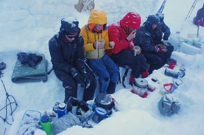
The next day the clouds set in for real, and stayed around for the next week. We spent a few hours in the tents, and finally mustered our energy to move camp a few km’s, passing between Moon and Earth and ascending the shoulder of Zygo to finally rest beneath the bump named Earth Peak. In the final section the wind was brutal and the blowing snow stung our faces. I was very happy to have brought my balaclava and ski goggles, perhaps not commonly used on spring traverses. I wondered if we would get to stand on the summit of Earth, right above camp, a status more commonly given to Mt. Everest, but it didn’t happen.

On the fourth day we woke up in a whiteout (again), waited for the weather to change and finally decided on a day trip to Harrison Hut. The ski down the Magic Carpet Glacier was a delight, and ironically the clouds hung out at our camp and above – below that the visibility was good. Arriving to the hut was a dramatic, perhaps even sentimental moment, or so it seemed to me. Ben had been trying to reach it for years, and Piotr was very interested in going there so that he could complete a Harrison to Brew traverse. It was also the only VOC hut I had not visited. Once we had arrived to the hut, the door had to be dug out which took about half an hour, since the snow reached the top of the door. The logbook revealed that most of the visitors to the hut these days are snowmobilers, who are not supposed to visit the area according to the Land and Resource Management Plan (LRMP) for the area. However, they appear to be treating the hut with respect. The entries in the logbook run back to ’83, when the hut was erected by the likes of Bruce Fairley. We also noted a group from the winter of ’97 that took four days to reach the hut due to deep snow, quite the slog. By the time we had looked around, signed the logbook, relaxed and snacked, a cold wind had started, and we headed back up to our camp, around 600m above us.

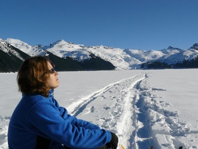
The previous day we had decided that no matter what the weather was the next day, we would pack up and head out in the morning and try to make some progress. The whiteout and intermittent blowing snow had been going on for days, but on this day there was a partial lull in the whiteout and we managed to get some decent views as we plodded on to the main part of the Pemberton Icefield, past Cloud Cap and Volunteer, to a camp by Conscience, with a view down the immense Squamish Glacier. Finally we were getting a glimpse of the views one expects on an icefield traverse. We had hoped to climb a few peaks on this trip, but the weather hadn’t allowed for it so far. Piotr and Sam headed up towards Conscience, but the rest of us were content to set up camp and build the snow fortress we had been building at each camp to protect us from the strong winds. We could see Piotr and Sam on the summit, and not long after they got back the clouds descended again, shooting down our hopes of a weather change.

Earlier that day Ben had discovered that his binding was loose. It was quickly ascertained that two out of the four screws that hold it in place had sheared off. The options were to continue like this and pray for the best, or remount the bindings, likely doing a half-assed job and thereby ruining the skis and wasting a day, to wait for the epoxy to set. Ben decided to try his luck, and from then on skinned and skied every so carefully, snowplowing down slopes that we were skiing down gracefully (or not), but thankfully the binding held.

On the sixth day we were completely socked in again, so we decided to take a tent day, in the hopes that the weather would get better. We amused ourselves by: sleeping, eating, reading (those of us who had brought books), playing cards and watching baro-TV. At one stage Piotr exclaimed, “baro-TV is so boring, it’s flat!” – the barometric pressure was constant (and low) for most of the trip, consistent with our (almost) constantly bad weather. In the late afternoon the sun came out for a bit, and Sam noticed a pattern, where the sun tended to burn through the clouds in the early afternoon, and that the whiteout came back once it started cooling down again. It was too late for us to move though, so we enjoyed the intense warmth.

It must be said that although we didn’t see the sun often, the solar radiation was intense, due to the reflection from the sun and fog. We each had our own way of dealing with the sun, for example Frances often used her “full coverage” set up due to her fair skin (but still got a bit sunburnt) and Piotr fashioned a hat out of a ziplock back and some snack wrappers. Champagne had a set of thin white long johns which reminded me of a ski soldier’s uniform.

Another setup which varied was our sleds. Since much of the trip was along a mellow icefield, we had decided to bring sleds. Some of us brought well designed “Baldwin-style” sleds, and others (such as me) brought large orange plastic bags. Both seemed to work with some success on the flatter parts of the trip. But skiing down with a sled is not a bargain, as it is continually trying to hit you in the legs, pass between your legs or in general throw you off course. Sidehilling is not the best either, since the sled always falls off to one side, I call this “walking the dog”. I was also somewhat worried that my plastic bag would go sliding down a hill into a crevasse or down the glacier, with all my essential gear in it.

On the seventh day we skied down the Squamish Glacier in a complete whiteout. This was expected to be a fun and easy ski down 12km of mellow glacier with glorious views, but we saw nothing… At the bottom of the glacier, after blindly following our compasses and GPS for hours, the sun came out, as predicted by Sam’s forecast. It suddenly got unbearably hot, and soon enough rocks and snow were rolling down the cliffs on our left. Our route passed below some large slopes that were warming up in the sun, and in the end we decided to set up camp despite it being early in the day, and cross below those slopes early the next morning. This gave us a chance to dry out our gear in the sun – our sleeping bags had become very moist from the condensation in the tent. The condensation often froze on the inside of the tent at night, and then peeled off onto us as we inadvertently touched and shook the tent in the morning.


Our last day (the eighth) was a long one. We woke up at 4am and were on the move by 5:30am, crossing safely below the now quiet and inactive slopes. We swung around the volcanic plug of Little Ring Peak, with beautiful views of Numbers behind us. Many of the peaks in the area are named after books in the old testament, including Exodus, Numbers, Torah and more. We had decided to take a low route which would get us out faster, avoiding the Callaghan Glacier. This involved passing through a small pass, but we were engulfed in clouds again. The pass was very narrow on that side, and guarded by steep slopes, but we managed to sneak through and on to the very windy pass. From there we skied down to tree line and then back up between Ring Peak and Callaghan and finally down to Ring Lake. Here Piotr and Sam left us to continue on their mission to ski from Harrison to Brew, for another three days. Somewhere along the route Piotr managed to get cellphone reception and the forecast, which was for sunny weather, so they decided to go along with their original plan.

From Ring Lake we still had a short ski down and then about 14km of xc trails to ski along, and it was already 4pm. In the end the trails went quite fast and we were back at the car at 7:30pm. We had managed to finish the traverse, under physically and mentally tough conditions, which perhaps ought to give one more satisfaction, but honestly I was wishing for sun 95% of the time. We stopped in Squamish for some food at the Shady Tree and drove back home. Ironically, the weather forecast for the next week was completely yellow: sunny every day!

4 Comments
Mom
Words fail me…..:)
Pingback:
Ski Doo
“The logbook revealed that most of the visitors to the hut these days are snowmobilers, who are not supposed to visit the area according to the Land and Resource Management Plan (LRMP) for the area. However, they appear to be treating the hut with respect.”
Thanks, but people whom are able to think for themselves realize that snowmobiling to the cabin doesn’t damage any land or resources – and I will continue to do so, no matter what some guys plan on a piece of paper says. Thanks also, for the air of prejudice, but not all who snowmobile treat backcountry huts without respect. Pretty sure there is an equal number of people who sled and people who ski-tour/hike/snowshoe/whatever that mess up backcountry spots. Some people’s children.
Gili
Thanks for the comment, but I respectfully disagree with most of what you wrote. I have nothing personal against snowmobiling, and I’m sure that most snowmobilers are good people. Each to their own, but we ask that you respect us and do not venture into a few chosen areas. The Harrison Hut was built by the Varsity Outdoor Club of UBC, of which I was an executive member for two years and have been an active member in for over seven. Like all VOC huts, the Harrison Hut is open to all non-motorized, non-commercial groups, and I ask that you respect that.
My disagreement with your position is based both on the sheer number of snowmobile pieces (plastic, metal, rubber, gas cans…) I have found in BOTH winter and summer in pristine locations, and even several abandoned snowmobiles. On too many occasions, I have unfortunately also managed to go on backcountry ski trips to places that snowmobilers frequent, and have been buzzed within short distance (see for example: http://inmagicland.com/2012/02/gin-peak/) as well as “enjoying” the completely tracked out slopes. Personally, I would prefer that there would be no motorized vehicles in the wilderness. Failing that, at least I would like them to be limited in the areas they go to, and the LRMP was designed to do this. British Columbia, unfortunately, barely enforces any regulations on snowmobilers, not in watersheds and not even in parks.