Brazeau Loop and More: Two Weeks in the Rockies
After our cycling trip we decided to chase the sun, which led us east, where it looked sunny. Originally we had planned to spend two weeks in the very remote Spatsizi Plateau Provincial Park, but the weather was looking bad enough to warrant changing our plans. Ironically, we had been in a hurry on our cycling trip in order to leave enough time for Spatsizi, but in the end didn’t end up heading to Spatsizi at all… On our way east we stopped at Moricetown, a first nations community, to buy salmon. First we bought fresh pink salmon, which was caught to the order by a youngster wielding a long pole with a net at the end (it looked easy). He was standing right on the edge of the raging Bulkley River, connected by a flimsy looking cord, in case he slipped. Then we managed to buy some delicious smoked and jarred salmon, made a by a friendly lady who showed us her smokehouse – an old shed lined with bright orange sockeye fillets on wires and a small fire below. When we reached McBride we could finally change into sandals and shorts – summer had arrived!

After a short stop in Jasper, our first day trip was to Wilcox Pass and Peak. It was gray and drizzling, but this had the bonus of keeping people away from this popular spot. We were already starting to enjoy the advantages of hiking in the Rockies, with very short access to the alpine. Just above the pass we saw a large group of mountain sheep, and the wind started picking up. Once we got up onto the ridge the wind was very strong, and we could see dramatic views of the Columbia Icefield on the other side of the highway. We continued along the ridge and then started traversing, aiming for Wilcox Peak. There were some interesting piles of striped black and yellow rocks that I named “tiger rocks”. After a while the trail seemed to peter out near a steep lingering snow patch which we were hesitant to cross, and it didn’t look like it continued on the other side.

I decided to try scrambling directly up, and Maya stayed below. A few meters up I stopped, unsure if I should continue, but it looked easy enough, so I kept on going. I passed a rappel anchor, used by a group that turned around from that spot, not a reassuring sign, and the rock seemed a bit loose, but I kept going, doing lots of class 4 moves to the top. At the summit I didn’t see a thing due to the fog, and turned around immediately, not feeling satisfied at all with the accomplishment. On the way down, I had a bit of a surprise, or should I say, an introduction to scrambling in the Rockies: the rock was absolutely rotten. Somehow on the way up I managed to find good holds, but on the descent everything seemed to crumble. I was dropping rocks left and right. I couldn’t communicate with Maya since she was too far below, but I thought she was safe. Somehow a small rock managed to hit her above the eye, narrowly missing a much more serious injury. This experience shook us both up considerably.

The next day we woke up to hard rain. We were about to head off on a 7 day hiking trip around the Brazeau Loop in Jasper National Park. This is an ~80km hiking loop that is often done in 4-5 days, and we added in another two days for side trips. We hadn’t packed yet and getting out of the sleeping bags was tough with all the rain. Luckily the campground had a large cooking shelter where we spread out our gear and had breakfast. Soon the rain stopped and we drove to the trailhead. Once we started hiking, we had some warm drizzle at first, but after that we had only sun and blue skies for the whole week, it was a delight. We reached Nigel Pass, and descended to the upper Brazeau River. The river was high, so we forded it easily using the (fake) Crocks that we had tied to our backpacks last minute. Later we discovered the delight of changing into them in the evening after a day of hiking in heavy hiking boots. We spent the first night at Four Point Camp, which we found a bit gloomy. We recommend spending time and cooking by the river, it is much nicer. The camps are well organized with marked sites, an outhouse, picnic tables and food cache. The trail was very easy to follow, well maintained (no blowdowns), signed, and most creeks had small bridges across them. A far cry from the bushwhacking, delicate route finding, and head-scratching “are we on the trail, or not?” that often accompanies our trips in BC.

We hiked along the Brazeau River on the second day, which wasn’t the most interesting but there were some views along the way to Brazeau River Camp. On the third day we set out on a day trip up a ridge to the NW of camp (off trail). First we hiked through open forest with lots of blow downs for a short section, but soon got out on to a steep grassy ridge that led us quickly out into the alpine. We could see the Brazeau River stretching out to the horizon (where we had come from) and the exquisitely blue Brazeau Lake, looking like a piece of polished jade embedded in the forest. We continued up the ridge, had lunch in a picturesque spot and then headed down a different ridge that led us to a horse camp and a trail back to camp, thereby completing a very nice loop, almost all off trail.

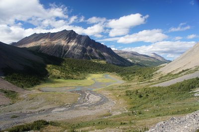
The next day we hiked past Brazeau Lake and then up John-John Creek (I wonder where that name comes from). There were huge steep rock walls on both sides. After a few kms we left the creek and hiked up to Poboktan Pass, a very wide and open pass, with lots of room for rambling, and great views of Flat Ridge behind us (yes, that’s the name of a peak). After a short descent we arrived to Jonas Camp. I was surprised by the bugs here – we had gotten used to the atypical lack of bugs in North BC and the Yukon (due to the cool summer). The next day we did a day trip up to Jonas Shoulder and NW along a long beautiful rocky ridge. At one stage we hiked through a “rock garden” – we were hiking on soft gravel and there were various rocky formations spread out around us in clumps, like sculptures. We continued along, enjoying the views: we could see the domed shape of Sunwapta Peak, and right down into Jonas Pass (our destination for the following day). The contrast between the brown rock we were hiking on, the snow on the mountains and the low grass in the pass was very striking. We came upon two mountain sheep, making good use of our binoculars. The wind picked up, and we continued hiking up and down small bumps on the ridge. We had lunch and a nap in a semi protected area on the last bump before the rock got steeper and loose.

After two nights at Jonas Camp, we hiked back up Jonas Shoulder, this time heading down the other side to Jonas Creek. The views this day were even more spectacular, since the sky was a vivid blue instead of a hazy light blue. Jonas Shoulder is a very impressive place to be, a little niche in the ridge with steep drops on both sides. We descended and continued along the valley to Jonas Pass and down Four Point Creek. It was very hot – we changed into shorts and took a quick little half dip in the creek, which was very cold. We descended back to Four Point Camp, the same camp we had spent our first night at. Here we reunited with a dutch couple that we had met the night before. It was their first overnight hike and they had forgotten their stove pump. We sat by the river, cooking dinner and sharing stories (they borrowed our pump). On the last day we hiked back out over Nigel Pass, the opposite of our first day. The Brazeau River was lower so we could rock hop across and we enjoyed the views of some big peaks (Mt. Alberta?). At the car we used the BBQ to make quesadillas with our left over tortillas and cheese – after five weeks of eating tortillas and cheese for lunch, the concept was getting a bit old (but I must say they keep well and pack well), but melted cheese on anything is a delight. It started to rain just as we were getting into the car, perfect timing!

Although a trip in the National Parks is more expensive than what we are used to in SW BC, there are advantages, such as the wildlife. At time it felt like a safari: we saw mountain goats, mountain sheep, deer and elk several times, right from our car. On one occasion we had just passed a sign warning of mountain goats on the road, and 100m farther we saw two mountain goats. It was is if when you go to the Rockies you pay, and they deliver… I had thought we would see many more people on the trails, but like everywhere, if one puts in a bit more effort, one can easily be alone. Also, for backpacking trips, one has to reserve a site in advance. Although this demands some planning, it also guarantees a very small number of hikers on the trail, and often we saw no one for most of the day. Contrast this with the crowds heading up to Garibaldi Lake and Elfin Lakes on a sunny summer weekend.

The next day, after replenishing our supplies, replacing our bear spray (the top had fallen off) and some information gathering, we headed to the Miete Hotsprings, to relax. The hot springs are very developed, it is basically a very hot swimming pool, but it was very welcome after a few weeks on the road and eight straight days of hiking. The next day we had planned a three day trip, but when we arrived to the trailhead it was snowing hard. We decided to take it easy that day and then do some day trips instead. Driving along the Columbia Icefields Parkway was beautiful, with a few cm’s of fresh snow right at the highway. At night the temperatures dropped and we found some ice on our tent and tarp in the morning. That day we hiked to the top of Mt. St. Piran, above Lake Louise. The Lake is a tourist madhouse. We heard one person in the parking lot who was very worried she wouldn’t be able to find the lake, despite it being 50m from the parking lot, with a huge hotel right there. After a few km’s of hiking we finally left the crowds, and were heading up gradual switchbacks and then talus to the summit. It was windy and there was snow on the ground, so we had lunch behind a neat rock wall and then took numerous photos of Lake Louise far below us, and famous mountains such as Mt. Lefroy, Mt. Victoria and Mt. Temple. They had a glorious new white coat on which contrasted nicely with the turquoise lake and brown cliffs around us.

On our final day of hiking we took a trip to the Kindersley-Sinclair col in Kootenay National Park. There was a warning about a grizzly in the area, so we made sure to make lots of noise. The trail up the Kindersley Valley wasn’t too interesting, mostly in the forest, and it was very cold. We had lunch at Kindersley Pass, a small forested col, and then arrived to the main pass, Kindersley-Sinclair col. From there we hiked and scrambled up a small unnamed summit, where we saw excellent panoramic views. We then hiked down Sinclair Creek back to the highway and our car – it’s a very nice loop. Our next destination was Radium hot springs. We cooked dinner in the parking lot and arrived to the hot springs at 9pm. We had a good soak, agreeing that the water was slightly less warm than Miete, but the pool was bigger and felt perhaps more local (but it is right on the road). It was Friday evening before Labor Day Weekend, so we knew we’d have trouble finding a legit place to camp (recreation sites were probably all full). We stopped at a campground to ask if they had room, which of course they didn’t, but the guard said that we could camp on a grassy area for free. Nice.

I should explain that we decided to take the long way back from the Rockies on a whim. When we were at Miete Hot Springs we heard two people chatting and one of them mentioned how there were fruit stands at every corner and plums and peaches galore in Creston. So, of course we had to go check it out. We managed to pick 50lbs of cherries and lots of peaches, pears and apples (all for $0.60/lb) and even some hydroponic strawberries. Finally, after half a day of picking fruit and gorging ourselves on cherries, it was time to continue the drive. In the evening we pulled into a recreational site near Hedley and miraculously there was a free spot there. The next day we drove back to Vancouver, making a stop to buy enough cheap salmon to fill up our freezer completely. Vancouver greeted us with 10 days of beach weather, a very welcome respite, and a reminder that despite the snow we had in the Rockies, winter was not quite here yet.

One Comment
Pingback: