Downton Creek: Hot Weekend and Fires Close By
On the August long weekend (yes, three weeks ago!) we went to the Downton Creek area for three days. We were there at the end of August last year and got chased down by a freak snow storm and very low temperatures. This time it was sunny with blue skies until we got into the alpine and it started pouring with no warning. We thought – this place is cursed! We found a boulder to hide under for half an hour, during which it rained and even hailed for a bit. Finally the sun came back out and we hiked up to a small lake, right below Linus and Faulty Tower with wide views down valley.

It was already late afternoon, but the flies were annoying us, so we decided to scramble up the ridge leading to Linus. There’s a lot less snow than in previous years, owing to the reduced precipitation and higher temps, so it was all annoying loose talus. We scrambled the ridge crest for a while, enjoying the exposed location. Then we figured we didn’t have time to go to the summit, since it was getting late, so we left that for the next day (turns out we were pretty close though) and found a good descent route on gravel.


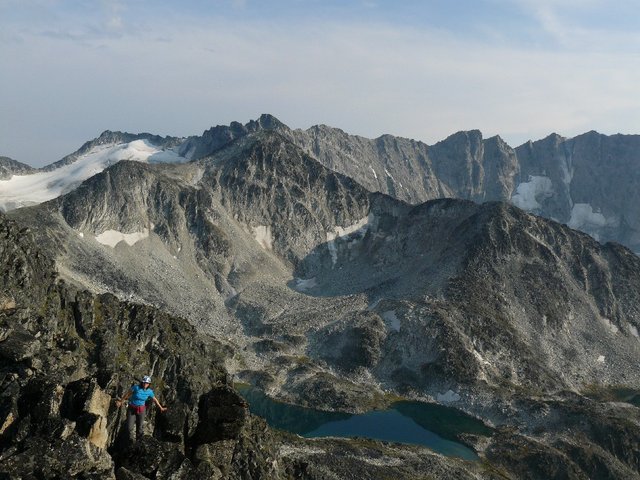
The next day we hiked cross country around the base of Faulty Tower and found some beautiful pink flower patches. From there we hiked up to the lake below Statimcets and up to the top. Previously when we were on Statimcets it was snowing on and off and we couldn’t see a thing – this time we enjoyed very nice views (albeit hazy due to smoke) of the peculiar lake in the Lost drainage and the mountains around. It was interesting to see the different rock types – Linus, Faulty Tower, and that whole area has white/grey rock, whereas the Statimcets/Seton side is all brown rock.
From the summit of Statimcets we scrambled along the beautiful ridge to Linus. First it opened out into a wide grassy ridge and then closed in and became a moon-like rock landscape and finally steepened and demanded some scrambling moves to the top. There was no summit register, but we did find an empty sunglasses case in the summit cairn, so we turned that into the register and left a pen too. We spent a long time on the summit admiring the views.

We descended via our route from the previous day, straight to camp, completing a very nice and recommended loop. In the evening it became windy, which was good since it took the bugs away. Later we suddenly noticed the smoke coming in from the nearby fires. It covered about a third of the sky and there was a faint smell of smoke, but it wasn’t too bad.
The next day we considered scrambling Soprano, but the views seemed smoky, and the route seemed like an abusive talus fest, so we decided to rather relax and leave early. We took swims in the tiny lake by camp and Holly lake and then headed down.
While driving down Maya noticed some raspberries on the side of the road, so we harvested the laden bushes until we got our fill. We later stopped in Pemberton to pick blueberries, and had a great Italian meal at Pasta Lupino in Whistler (highly recommended – fresh pasta, inexpensive). When we got home we discovered that a few hours after we had left, that same road (Duffy Lake Road) was closed to all traffic due to fires.