West Kootenays: Adventures in the Kootenays
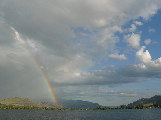
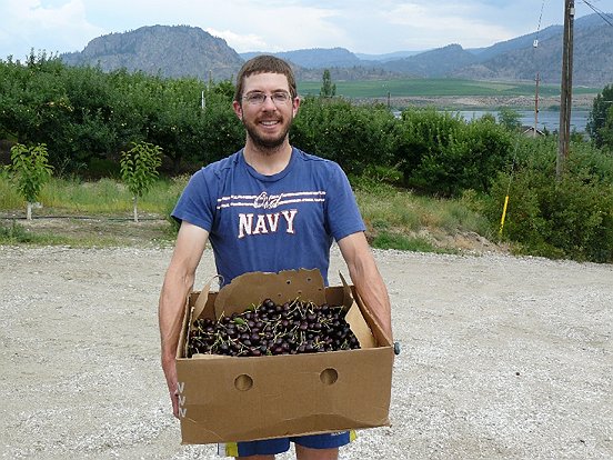
About two weeks ago we returned from three weeks in the Kootenays. The days before we left were a flurry of activity – we subletted our apartment, so we had to tidy and clean up, dehydrate food for the trip, pack and tie up all sorts of loose ends (such as doing our taxes three months late…). Finally we managed to leave in the early afternoon, and drove east through the Okanagan. We stopped near Osoyoos to pick purple and sweet cherries, and bright red apricots. A wonderful rainbow greeted us next, followed by lots of rain into Grand Forks where we spent the night. The next two days were cool and somewhat rainy, which was good since we had a large amount of fruit in the car…
Days 2-4: Up the Slocan Valley
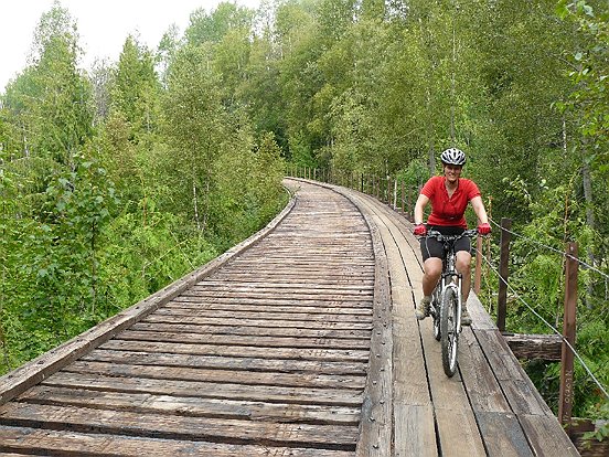
The next day we set out on a bike ride from South Slocan to Slocan, along a deactivated railway, with good views of the Slocan River. We hitchhiked back at the end of the ride, and drove north up the Slocan valley, to the very small and charming towns of Slocan and New Denver.
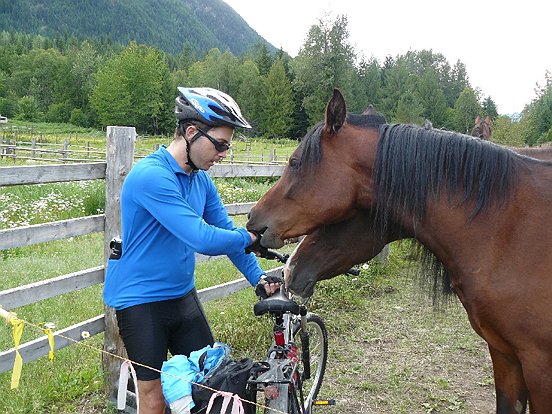
Our next ride from Three Forks to Nakusp was quite eventful: first there was a cable car crossing over a raging river, then a ghost town marked by a pile of logs and metal junk, then some “bicycle bushwhacking” where the trail had become overgrown, a hip deep section of water where a culvert had burst, an encounter with some enthusiastic horses and an electric fence. Finally we arrived to Nakusp and waited for a long time for a ride. The driver was nice enough to load up our bikes into her pick up truck, which saved us driving back and forth to get the bikes. By then it was 9:30pm, and we were at New Denver, about 8km downhill of our bikes – so I set out on my own on the bike to get the car.
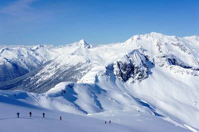
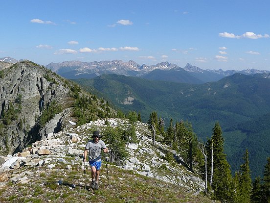
On the third day we went to Idaho Peak, which is a popular hike due to the easy access and excellent views and a colourful wildflower display. The road was blocked by snow (even in mid July) a few kms from the trail head, so we got to hike a bit farther. The summit provides sweeping views of three parks: Valhalla, Kokanee Glacier and Goat Range.
Days 5-9: Five Days in Kokanee Glacier Provincial Park
The next day we finally hit a forecast of “Sunny” so we headed off for a five day trip in Kokanee Glacier Provincial Park. We chose to enter through the backdoor – the Nilsik Route, which is not used often and is not maintained by the park, hence it is somewhat overgrown. We set out from the trail head, where we had camped the night before, and didn’t forget to surround our car with chicken wire against rubber loving critters. The route was easy to follow, but covered with berry bushes in places. In the sub alpine the route petered out and we continued cross country into the alpine, where we camped with nice views of the Nilsik valley and basin. Before us, and above camp, we saw a beautiful and snowy notched pass, which I assumed was the pass described in “Where the Locals Hike in the West Kootenays”, the guidebook we had gotten the idea for the trip from.
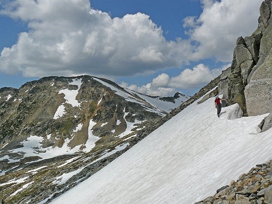
The next day we kicked steps in snow up to the impressive pass, which has a large green mossy boulder on its side. In fact, we were looking for the pass between Outlook and Sunset Mtns, but this was the pass between Outlook and an unnamed Mtn. We had planned to scramble up Outlook and then Sunset, but the steep ridge did not look like an easy scramble. Furthermore, the other side of the pass dropped down steeply to a forested valley, without the expected mellow alpine basin. For various reasons we ended up without a good map of the area, but that was all for the best since we would otherwise not have gone up to this beautiful vantage point. Somewhat confused, we ditched our packs and scrambled up the north ridge to the summit of what we realized was Outlook Mtn. The scramble was fun class 2-3 moves on somewhat loose rock and soon we were on the summit, surveying the wonderful view. Now it was obvious that we were looking down to Glory Basin, and our intended route.
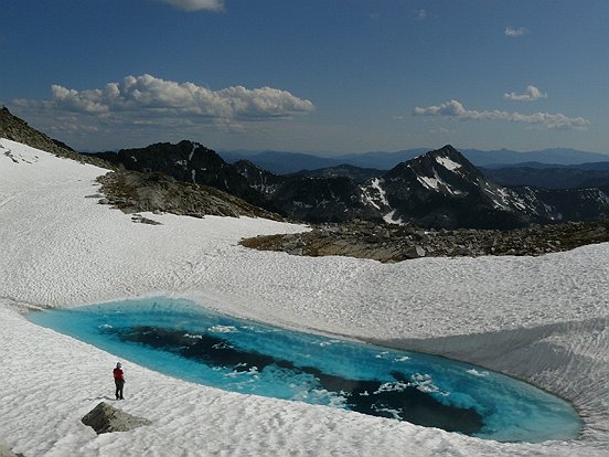
We scrambled down to the Outlook-Sunset col and contoured back to the notched pass on snow and talus, to get our backpacks. After lunch we hiked back to the correct pass, where we had a rest beside a beautiful turquoise lake. From there we scrambled easily up to Sunset Mtn. The registers on both these mountains (Outlook and Sunset) show that they are ascended only a few times each year, and almost always from the Sapphire Lakes direction (our destination). After descending, we continued rambling down Glory Basin, towards Sapphire Lakes, passing numerous tarns and hiking mostly on snow. We found a nice campsite on grass, not far above upper Sapphire Lake. We watched the sunset from a spot above camp.

On the third day we descended to Kaslo Lake along Outlook Creek. There is a faint trail and cairns, but there was still a lot of snow so we just followed the creek, enjoying the waterfalls and pools. Eventually we caught sight of Garland Lake and met up with the main trail running from Kokanee Lake to Kaslo Lake. We hiked to Kaslo Lake, and saw a couple with day packs, the first people we had seen since heading out. We skirted the lake and made a stop at the huge Kokanee Glacier Cabin, mostly in order to get some information about possible routes in the area. At the cabin we met the custodian, who told us that the park had been almost deserted for weeks. This was due to a landslide on the trail from Kokanee Lake, combined with the longtime closures of Enterprise FSR (now open) and Keen Creek FSR. Entering the hut, we were shocked to see couches, a refrigerator, and an oven – not what you expect after a few days of hiking in the wilderness. Apparently the hut has a small hydroelectric electricity plant.
We hiked up to Enterprise Pass to have lunch, and debated our possibilities. We decided to hike up to a peak named Granite Knob, reached by a scramble up a ridge, starting directly from Enterprise Pass. Once on the ridge it was easy hiking along an open ridge with some beautiful burnt trees, with nice views of the Battleship and the Giant’s Knee. Unfortunately some ups and down over bumps in the ridge were involved, but eventually we found ourselves on the last rocky section, and an easy scramble to the summit. By this time it was the early evening, so we didn’t linger long. On the way down the mosquitoes were driving me crazy. When we got back it was almost dark, and I was happy for the little light we had which allowed us to find the correct way down and avoid the cliffs. Back at Enterprise Pass and our backpacks, we decided we were too tired to go anywhere and it was dark anyway, so we just set up camp close to the pass. There was no running water, but we had enough for dinner.
During the night it rained hard, and by the next morning the little dry channel by our tent had turned into a small creek, which was good since we didn’t have to go looking for water. We stayed in the tent waiting for the rain to subside, but it kept on coming and going. After half a day in the tent we decided enough was enough, donned our full battle gear and headed out into the fog and rain. We hiked up the trail, and reached a point where it crossed the creek but the creek was very high, probably due to all the recent rain, in addition to the usual snow melt. We hiked up along the creek and found a better place to cross higher up. We followed the trail to Sapphire Lakes, spotting some recent goat tracks in the snow. At an unnamed pass we left our packs and scrambled easily up Mt. Giegrich. We were hoping for some grand views, but the clouds lifted only partially. We returned to the lower Sapphire Lake where there is a small campground with an outhouse, bear cache and nothing else (not much signs of use either). We found a nice camping spot, and were just finishing our dinner when it started pouring again, this time with thunder and lightning.
On the last day we hiked to the end of lower Sapphire Lake and spent some time looking for the Lemon Creek trail on the north side of the outlet creek, but once we realized it is on the south side, it was easy to find. The top part of the trail was indistinct, but lower down we came to an old mining cabin and from there it was much better. We reached the place where we were supposed to “rock hop” across Lemon Creek, but there was fast rough water there, and above and below. I looked around for a while for a better place to cross, but it became obvious that we had no choice. Here I had an “Into the Wild” moment – in the book and movie (based on a real story), the proponent tries to hike out but finds that the river is too high to ford, so he cannot return the way he had come, with dire consequences.
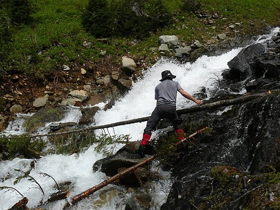
What to do? I found some logs that the river had swept down stream and used them to construct a small but solid bridge. This worked well, and we crossed safely to the other side. The rest of the way was uneventful, and we were back at the car in the afternoon. We had hiked five days mostly in the alpine, scrambled four peaks and saw only three people. The only part that we had hiked twice was the first 45 minutes (aside from side trips to peaks), making for a very nice loop.
Days 10-11: St. Leon Hotsprings and Saddle Mountain
We were in need of a short break, so we drove past Nakusp to the St. Leon hot springs. These are privately owned but discretely open to the public. A short downhill hike leads to the guitar shaped pool. The water was hot, and especially so on a warm day, so we made good use of the watering can and a pipe bringing cold water from a nearby creek. On the way down we picked some delicious thimbleberries.
The next day we crossed the Lower Arrow Lake ferry and drove up a logging road to the trail head for Saddle Mountain. At the top there is a historical fire lookout and many of the previous lookouts carved their names into flat rocks nearby. There were good views all around and we took a short scramble to a sub-summit. The next day was Maya’s birthday, so that evening we had a birthday dinner at a nice Mexican restaurant in Roseberry.
Days 12-15: Four Days in Valhalla Provincial Park
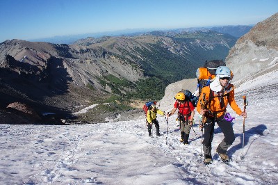
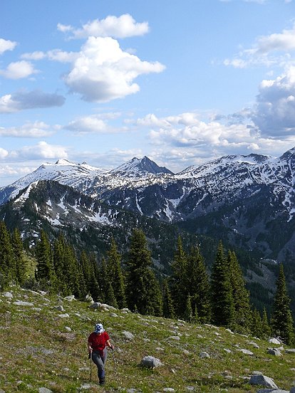
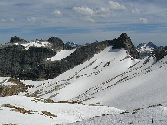
We drove up to the Gwililm Lakes trail head for a four day hiking and scrambling trip in the Valhalla Provincial Park. We got a late start, and hiked past Drinnan and Wicca Lakes, with good views of Drinnan Peak and Gregorio Mtn. We camped at Gwillim Lakes, where we stayed for three nights, using it as a basecamp for nearby scrambles. The next day we hiked up to Upper Gwillim Lakes and the Black Prince-Lucifer col, crossed to the other side and hiked on snow towards Mt. Bor, crossing some steep slopes. I remarked that in Israel this would be considered real mountaineering. The last section involved some moderate scrambling onto the narrow summit ridge. From the top there were very impressive views of the Devil’s Range. Many of the peaks there have sheer granite faces.
On the way back a funny thing happened – we noticed people on the summits of Lucifer, Black Prince and Trident, a rather weird coincidence, considering that most people who come to this area hike to the lakes and back, since not much information about the scrambles is available. That evening we discovered that a group of ten or so members of the Kootenay Mountaineering Club (KMC) were up there for a weekend trip. The next morning we chatted with a couple from the group, and then discovered that they are Madeleine’s parents (from the VOC), a funny coincidence.
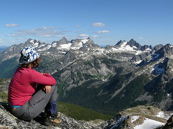
The next day we hiked to the lakes west of Gwillim Lakes and scrambled along the ridge to the summit of Black Prince. From there we got a good view of Mt. Bor and part of the KMC group who were returning from that peak. From there we continued along the ridge to the Lucifer-Black Prince col, which involved some interesting down climbing (looked like a cliff from the bottom) which could have been bypassed. Our next destination was Lucifer – we dropped back down and skirted around onto the easier side of the mountain. From there we scrambled up the ridge, passed one interesting exposed move and continued to the top of this pointy peak. Even better views of the Devil’s Range than before, we’ll definitely have to come back for more! On the way down we saw two mountain goats. We took the next day easy, reading for a few hours in the sun, and then had a refreshing swim in Wicca Lake, and hiked down.
Days 16-17: Cycling from Retallack to Kaslo, Gray Pass Summits
The next day we rode our bikes from Retallack to Kaslo, along an old wagon trail. It was very hot, we passed a neat fence made of old skis, and ate lots of saskatoons. In Kaslo we took a swim in the lake, had an ice cream and tried to hitchhike back to Retallack on a small road with not much traffic. After about two hours a woman stopped, said that she had seen us walk up the road two hours earlier and would take us specially even though she wasn’t even going in that direction. When I asked how much she wanted for gas, she said not to worry about it and “pay it forward”. A week or two later I picked up a homeless guy who was trying to walk from Squamish to North Vancouver (over 50km), and had a weird story about falling off an oil rig and being in a comma for six months. We slept at the beautiful Fletcher Falls Recreational Site. Free camping, right on the lake and with a large waterfall nearby.
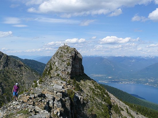
The next morning we crossed the Balfour ferry, and drove high up to Gray Pass. From there we hiked cross country to th south summit, then back down to the car and up to the north summit. We got some nice views of the Purcell Mountains. From there we drove to Nelson and camped at the crowded municipal campground. It’s a nice town, but I’m not sure what all the hype is about (then again we were only there one evening).
Days 18-19: Cycling from Nelson to Salmo, Old Glory Mountain
The next day we drove up to Mountain Station and rode to Salmo. Just as we were leaving, a woman came up to us and warned us that perhaps we shouldn’t ride in that direction, since a grizzly with two cubs had chased down someone the day before. We continued, making some noise, and had no problems. Later in the day we noticed a man coming towards us with two dogs, and another larger dog. That turned out to be a bear. We stopped to briefly talk to the guy, who said “the bears are no problem” and then another bear, larger than the first (the mother?) showed up. No real choice here, we kept on going and it scampered off. We called this the “Bear and Berry Trail” due to the bears and the many berries: thimbleberries, raspberries, saskatoons and strawberries that we found along the way. While we were eating lunch at the small town of Ymir it rained hard, but we were under a shelter, and by the time we were done it had weakened to a drizzle. In Salmo we caught a ride within a few minutes with a mountain bike aficionado, who I think was laughing at us for not riding back to Nelson along the road, since he does all sorts of long races and such.
We drove to Rossland and seeked out the local campground where we got a surprise: there was a cherry tree, brimming with fruit, right above our tent site! How good does it get? Needless to say I cleaned out the tree – no one else seemed to care about this treasure. The next morning we drove a short way to the Old Glory trail head, and hiked up to the popular Seven Summits mountain biking trail, and on to Old Glory Mountain and the lookout on top. On the way we came upon a weird sight: a pika seemed to be stuck in a hole and trying to wiggle out. I was debating whether to help it out, when we understood: it was feeding its young ones, and was scrambling to get out to guard them. While we were eating our lunch on the top, we saw the weather change: it was raining in the distance all around us, creating a very special lighting effect, but we were lucky and the rain never came close. On the way down we took some neat photos of the gnarly burnt trees.
Day 20: Cherries (again!), and back home in a storm
We drove to Midway, and seeked out the nice campground we remembered from a previous visit. Unfortunately this time it was full, but we found a nice grassy spot on the side. Maya remarked how green the grass looked. Around 2am we awoke to what sounded like missiles hitting our tent: sprinklers were spraying our tent every 10 seconds or so. After a while we decided we’d have to move the tent, so I dragged it away, and the rest of the night was peaceful. The next day we drove to Osoyoos, said hi to our friends Jose and Andrea and went back to Charlie, the same guy we had picked cherries from on the first day of our trip. This time we were free to pick as much as we wanted, and since it was the end of cherry season the price was ridiculous: 50 cents a pound. I sat down on the ground and pulled the cherries straight into a bucket. We ended up with 40 pounds of cherries and a sore stomach (for me), continued to the peach and apricot trees, picking up another 15 pounds or so of apricots.
At this stage we were ripe for a swim in the lake, and thought we’d wait until Penticton, but when we got there it started raining violently. It was a surreal sight to see so many people walking along the road covering their heads with blow up boats and inner tubes. Our swim at the beach turned into lunch at the mall while it hailed outside. Most of the drive back it rained like crazy, and even with the wipers going on maximum it was still difficult to see anything, and the road was like a swimming pool. In fact, several people had stopped on the side of the road to wait it out. Back in Vancouver we watched the lightning show and the orange sky that said to us: welcome back!