Slim Creek to Wolverine Pass: Ridge Walking in Paradise
Maya and I were entrusted with entertaining our friend Yaron for two weekends while his wife and children were away. Last year we had spent a long weekend in the South Chilcotin, and I was just waiting for an excuse to return. It also seemed like snow levels would be lower there and we could actually do some early season scrambling. We decided to make it into a long weekend by taking off the Monday too, preparation for the next weekend: the super long weekend (Sat-Tue) for Canada Day.

We left Vancouver at 5am and made good time to Pemberton. From there we drove 60km on gravel roads following the Hurley FSR to Gold Bridge. After that we still had another 30km of logging roads to drive on the Slim Creek FSR, all in all about 5 hours of driving. I couldn’t get any updated information on the road condition and was pleasantly surprised to find that we could drive right to the end of the road in a 2WD. Well, not quite – at km 28.5 there is a bridge which was blocked by huge cement blocks. There was a bulletin on Bivouac in September 2007 saying that this bridge was “down” and supposed to be rebuilt (fixed?) by the end of that month. The bridge looked sturdy to me and doesn’t look like any work has been done on it recently. We parked the car (no other cars there) and walked the 3km or so on the logging road to the trailhead. There were many signs of bears – footprints and scat.


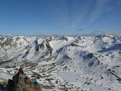
The trail follows Slim Creek up the valley, staying on the north side. There were some very boggy spots (gaiters appreciated) and some short overgrown sections, and gradually the flagging became far in between. We reached the cable crossing marked on the map, and for future reference I noted that it seemed it would be fairly easy to cross with a harness and a regular climbing carabiner. From there we continued up the river until we reached a tributary which was the sign for us to start heading uphill towards Leckie Lake. On the map there is a symbol of a footbridge, so we were expecting to see a sturdy bridge over Slim Creek, when in reality there are just three logs there to cross the tributary, not the main river. From here the trail disappeared almost completely, and we just followed the tributary up towards the saddle we had seen from a distance. Eventually we broke out of the trees and got some magnificent views of the Dickson Range. From there we followed some snow patches to our intended camping spot beside Leckie Lake, which has panoramic views and is just a spectacular location.
On the way up we noticed an appealing ridge on the north side of the valley which seemed like it would make a good scramble. The original plan for the next two days was to cross Wolverine Pass and then head NW and S back to Slim Creek where we would camp and then head back. Yaron suggested that instead we could leave our gear at this camp, hike up to Wolverine Pass and then traverse the ridge we had spotted on the way up straight back to camp. This plan maximized our time in the alpine and cut out some hiking along Slim Creek which would probably have been a bit of a marsh.

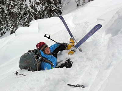
So, the next day we headed up the valley towards Wolverine Pass, mostly on somewhat soft snow. Marmots entertained us with their whistling on the way. At the pass we took a short break and noticed a halo around the sun, which persisted for most of the day. From the pass we headed up our chosen ridge, angling to the SE to bypass a cliff. On the way up and on the ridge we got excellent views of Gun Mtn, and many other peaks in the area. We hiked and scrambled along the ridge which was mostly easy going, but there were several bumps we ascended and then descended. One short rocky step (class 2-3) was a little more difficult. The only sign of human beings were a few orange flags which must have been put up by heliskiing operators to mark good runs. Eventually we passed above our campsite, went up to the next bump and decided to descend. The descent was easy, on soft soil and long snow patches, some of which we glissaded (not easy with the soft snow), finally getting some use out of our ice axes (could have easily done without them).

The next day we reversed the route from the first day. We lost the trail briefly several times, and I wished I had brought some flagging tape mark some key points on the way in. On the way up the weather was somewhat grey, but now with the blue skies, the views were re-appreciated. Another difference between the way up and the way down was a deserted snowmobile which we had spotted on the logging road on the first day. I had noticed that it had some shallow scratch marks on the seat at the time. Now, two days later, we were surprised to find the seat torn to pieces. Evidently one of the bears in the area has a strong sense of justice.

We returned to the car after three amazing days during which we saw no other people. On

the way home the windows and wipers stopped working for a while. This did not make us happy, with three sets of stinking hiking boots and socks in the car. Eventually the car sorted itself out and we could breath again. We saw a bear on the Hurley and stopped in Pemberton to “show” Yaron the amazing chocolate mousse in a cone made of chocolate (how come no one thought of this before?!). We arrived back to Vancouver after 11pm, ready for a big meal. We looked around for a place to eat, and settled on Kisha Poppo (Japanese) which offered a late night all you can eat menu for around $12 – just what we needed. Drove home bleary eyed with full stomachs and straight to bed – another memorable weekend for the books.
One Comment
Pingback: