Tsylos and Wells Gray: Getting Lost and Meeting Friends for Life
The trail head is a long day’s drive from Vancouver (11-12 hours), which we split over a day and a half. On the first day we drove almost to 100 Mile House, found a deserted and dark spot just off the highway and slept in the car (the wonders of station wagons). The next day we drove to Williams Lake where we stocked up on brochures and maps (at the info centre), discovered free internet (same place), and checked out the local swamp park (lots of birds).

From there we took highway #20 which goes to Bella Coola. We only saw two cars going in the opposite direction even though we drove that road for 90km, and picked up a lonely hitchhiker (no public transport). At Hanceville we turned onto the Nemiah FSR, a good gravel road. Along the way we passed a dilapidated village which had humorous (at least to us) signs encouraging reading, such as “travel the world by reading” (read: you’ll never leave this place).

After about 90km we turned onto the Elkins Creek FSR (no sign) a rough gravel road. This road is rough enough to keep the driver alert, but still passable with a 2wd. We drove this road for about 40km, passing several lakes – Taseko, Lastman and Fishem. On the way we met the manager of a pack horse outfitter who told us about several recent Grizzly sightings, and that we would not be able to make it up the last 7-8km to the trailhead. We also saw a black bear on the road. He didn’t seem concerned at all about the car and continued munching on a plant on the side of the road. Eventually he ran away.
That night we camped near an old airfield (just a large flat gravel area) on the shore of Fishem Lake. There was a group of three men from Williams Lake there with their ATV’s, just exploring the area. They told us that there is an active mine (with UBC students working at it) further along the Elkins Creek FSR. I asked them if they would agree for us to pay them to take us up to the trail head, but they insisted on taking us up for free.

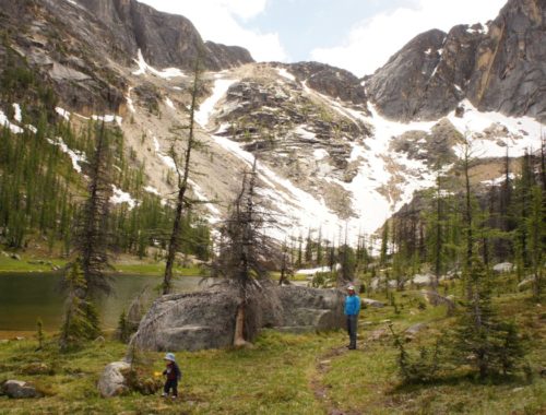
The next day we were up early, and were ferried up on the ATV’s (no helmets). The road is uphill almost all the way and in the forest with no views, so we were very thankful for the ride. They took us to the end of the road (it is washed out after that), and we began hiking up the Tchaikazan valley. The trail took us through a forest, every now and then passing through a swampy meadow and gaining views of the beautiful and very wide valley. At some stage we reached the outfitters hut, where a fire was smoking. We spoke to the guides for a bit – the clients had gone up towards Spectrum Pass. From there we left the bottom of the valley and began ascending along a tributary. As we gained in altitude the views became better and better. Just before we broke out into the alpine we met a family with three children, the man carrying a rifle (against the bears, he said). They had hiked up to Spectrum Pass, and then traversed the ridge and rejoined the trail further down.

We camped close to the treeline, as high as we could but where there were still trees to hang our food from. We then discovered that Maya’s eye was very swollen again, just like it was a two months ago when we were cycling the Kettle Valley Railway. She took an antihistamine and we hoped for the best.
The next day we scrambled up to a pointy unnamed peak at the head of the valley. The route is obvious – up a ramp to the main ridge, along a plateau and then up the final ridge on large and unstable boulders. The view from the top was absolutely incredible – we could see the huge turquoise Chilko Lake, Dorothy Lake – our objective for the next day, and many peaks and glaciers. We had lunch on the summit and Maya took a nap (the allergy was taking its toll). The weather was perfect – blue skies with some clouds and warm but not too hot, with a very light breeze. Eventually we had to head down.

On the way up we had continually looked back and spotted the tiny yellow dot that was our tent. But on the way down we could also see a red dot. This confused us for a while and we made up wild stories about the things that could have happened to our tent. We had not expected to see any other hikers, least of all this couple in their sixties which had set up camp not far from us. Later on the guy, Warrick, came over to chat.

On the next day we hiked up to Spectrum Pass – from this camp and on there was no trail, but the route was obvious. On the other side of the pass we descended along a stream, and had to cross it several times when the sides of the valley closed in. Eventually we found a trail, which took us across a tributary. From there it seemed like there were two trails – one going up along the small tributary (which was the wrong direction) and another going down the valley we were descending. We took the second one, but after a while the trail petered out and we were inadvertently linking game trails and eventually bushwhacking. By the time we had realized what we were doing, we had spent a long time hiking down this dead end, and didn’t really feel like returning the way we had come. So… we continued bushwhacking, promising ourselves to find the trail later on. This is where we broke our custom that when we lose the trail we backtrack to the last place where we were on the trail for sure. One pays for mistakes…

The going was very tough, as we were close to the river (it became bigger as we descended) and had to break our way in the dense forest, and go up or down where there was a tough section. It was exciting to be in uncharted territory, and there were many animal footprints, scat, and I even found a set of horns. A few times I tried climbing higher to where I thought the trail should be but couldn’t find it (should have gone further, I guess). After a while we met up with the large river we knew we would have to ford, and were hoping to find the trail at this point. unfortunately this didn’t happen, and we plodded on.
At one stage I wasn’t paying enough attention and slipped and twisted my ankle. It hurt a lot at first, but then subsided somewhat, but I could feel something was wrong. Later on I discovered that I had sprained my ankle, and could continue but at a slower pace and had to endure some pain with each step. After a while we got to a cliff that forced us to climb up high. From there things got better – the forest was a lot less dense, we found a source of water, and finally stumbled onto the trail. We had spent about 5 hours bushwhacking. It was already getting late so we hiked faster and pitched our tent on the shore of Dorothy Lake at 20:30, with less than half an hour of daylight left. As we were preparing dinner the pain set in, so I took two Ibuprofen, wrapped up my ankle with a wet sock and elevated it for the night. We had planned our hike to be a maximum of 7 days, but we were making faster progress than expected, so this shrank to six days. Now we decided to cut out another day, which we had planned to use for a day hike to Chilko Lake.

The next day we hiked along Dorothy Lake and reached Yohetta Lake, where we found an amazing cabin, fully equipped with beds, linen, radio, solar cell, a shower, and a boat house. We managed to lock ourselves inside the cabin, and it appeared that there was no way out. I had a creepy feeling that someone had closed us up inside (with all our belongings outside). I managed to climb out through a window, only to discover that there was a piece of string going through a hole in the door. Pulling on this string from the inside raises the bar on the outside which locks the door. So we weren’t really locked inside… Kind of stupid, but provided some good laughs.
This section of the hike was a bit boring as it was in the forest the whole time, with only a glimpse every now and then of the lakes and peaks. Just as we reached the clearing where the second cabin is, I saw a bear running into the woods, but hadn’t seen enough to decide if it was a grizzly or not. When we got to the cabin there was a sign posted saying “Beware Large Grizzly in Area!” with a skull and cross bones on it. We put up our tent beside the lake not far from the cabin, just as it was starting to rain. While we were cooking we thought it over and came to the conclusion that perhaps it was the same bear and that he might have gotten used to searching for scraps around the cabin. We decided to sleep in the cabin, and took down our tent. This cabin was just a shack compared with the previous cabin, but it suited our needs.

The next day we started early in order to leave enough time to retrieve the car. The trail gradually became wider, as it turned into an ATV trail and then a (very rough) gravel road. We met up again with Warrick and Jan – they had climbed the unnamed peak we had told them about, and then managed to catch up with us. We hiked the rest of the way back to the trail head with them. They invited us to join them and camp at Tuzcha Lake, very close to the trail head. I had to hike 8km back to the car, but it was easy and fast and took me only an hour and a half even with a sprained ankle. Warrick and Jan had stashed a bicycle at this end, but their car was way up high so he had to cycle 15km, the last part all uphill. We met up again at the lake, put up our tents and it started raining and was quite cool. They went out in their canoe to catch dinner, and came back with two Rainbow Trout. I made rice noodles in coconut milk with peas, and we heated up some corn from a can. The fish was so tasty, I don’t think I’ve ever had such fresh wild fish (caught an hour before cooking).
Warrick and Jan are a couple from New Zealand originally and live on Vancouver Island. They have done quite a lot of travelling, as they spent several years on the road, travelling from Vancouver down to South America, lived in South Africa for a year, and then travelled back up Africa, and on to Europe. Their last trip was to the Far East, about the same time we were there. They have some good travel stories, like being in Uganda in Idi Amin’s time and unknowingly taking a stroll in Amin’s private gardens and getting a ride with his secret police.

In the morning they woke up early and came back with a very large Bull Trout for their dinner and another Rainbow Trout for us. We didn’t have a way of keeping it cold so we had it for breakfast, after the porridge. From there we drove back the way we had come, back to William’s Lake where we went shopping for some real food – eggs, potatoes, meat, pancake mix. We went to the hospital to try and see a doctor but they had more urgent cases, so we continued.
Our next destination was the Wells Grey Provincial Park. We had heard barely anything about this park (basically saw it in a brochure at the info centre), even though it is quite popular with Canadians. The main reason we were going there was to do a white water rafting trip which Maya was especially keen about. When we got to Clearwater we signed up for a full day rafting trip for the next day. After that we explored some of the waterfalls that the park is famous for – Spahats Falls which are a very short walk from the car (like many of the falls), Moul Falls which is an hour’s hike and you can hike right behind the falls. After Moul Falls we followed a side trail going to McDermide Falls (or something like that). On the way down I we startled a mother bear and cub. The cub climbed up a tree with surprising agility, and the mother took a good look at me and ran the other way. At this point we decided it might be in our interests to turn around. 🙂

The rock in this area is basalt, due to the volcanic activity, and is very different from other places we’ve been to in Canada. After that we drove up some gravel roads to the Forest Service Recreation Site at Lolo Lake. These are free, small but maintained campsites. This one was next to a beautiful lake and we were happy to be the only ones there.
The next day we met up with the guides and group of Interior Whitewater Expeditions. They took us in an old and rattling school bus on a gravel road along the Clearwater River which we would raft down later. We stopped on the way to look at some of the rapids. The rafting started with a safety talk, and then a calm section. After that we hiked up to… Moul Falls, the same waterfalls we had been to the previous day! But this time we were wearing wetsuits and helmets, so that we could actually get underneath the waterfalls which was quite exhilarating as the force of the water pushed us down. The first rapid was Saber Tooth, the biggest rapid of the day (class 4). There were two huge waves, and Maya and I had tactfully gotten the front (the most exciting) so that we got very wet. After that there was the middle canyon with many good rapids, lunch, body rafting a class II rapid (breathe when the wave takes you low…) and cliff jumping.

We took the next day easy as I had gotten a nice knock on my foot so I wasn’t sure I could do any long hikes. In the morning we went to the health clinic, and a doctor said that nothing was broken, it was just a sprain, but it would take several months to half a year to heal completely. One of the river guides had told us about a stone bridge high up above the valley that you could hike onto easily, and drew us a map. We had lunch on top of it. It was a great viewpoint, and this day proved to be one of the hottest yet, a nice change.

From there we drove along the park road stopping at Helmcken Falls and Dawson Falls. For once we camped at a paid campground on Clearwater Lake. The next day it rained the whole day, which didn’t stop us from doing a long day hike, the first section along the Clearwater Lake being the nicest, but later we had a long slog in the woods and views were minimal due to the fog (and it was raining). We went back to Lolo Lake for the night, but there was a noisy group with ATV’s, dogs and children, so we had dinner there and drove our car further up the gravel road and slept in the car. There was supposed to be a meteor shower that night, so we got up at 3:30 but it was too cloudy, then at 4:40 again and it was much clearer, but we only saw three shooting stars in about half an hour. The moon was almost full which interfered too. The next day we went to the Farmers Market in Clearwater where we bought plums, tried Rainbow Loaf (beet and zucchini), and bought a huge Zucchini. The drive back was quick, just five and a half hours, and we stopped for pizza at Chilliwack, and of course fuel – if we pass by we always stop there to fill up as they have the cheapest fuel anywhere in the area.